Use the trail map
together with the detailed descriptions to follow the trail.
Tatlısu
Trail
Trail
Info:
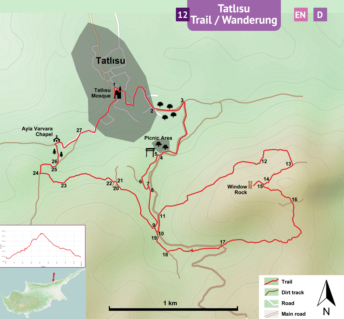
Start/End: The trailhead for this trail is the village square in Tatlısu Village.
Distance: 9 km
Duration: 4 - 5 hours
Ascent: + 550 m
Difficulty level: Moderate / Difficult
Tatlısu
Village Center (1) – Open Space (9)
The trailhead is the village square (1) of Tatlısu. Facing the Tatlısu Camii (mosque – formerly an orthodox church) turn L on “Cumhuriyet Sokak” and walk down the street and curve R towards the underpass. Turn L on “Turgut Reis Sokak” and then turn R. Walk on the asphalt to make a big curve around a ravine to come to the sign of “Kocatepe Sokak”. Follow the street up curving R on a moderately uphill and straight street towards the mountains. Pass the small village houses and turn L onto a dirt track (2) starting near an old telephone pole. There are green-white paintmarks, yellow arrows and red dots on this trail. Follow the stony dirt track uphill with scattered carob trees on both sides. At the junction (3) turn R. Continue climbing up and stay on the main track up to the picnic area. In the picnic area, there is an information board, olive trees and several seats. At the information board (4), turn R and walk down to the trailgate (5) nearby, which says “Tatlısu Parkuru” (means Tatlısu Trail). Walk down the stairs passing under the trailgate and curve L onto a path towards the mountains. Follow the narrow path up on a moderate slope through the woods. After a little while, arrive at a junction (6) with a dirt track. Turn L and continue on the tracks curving L downhill and then up to curve L to come to a junction (7). Turn R on a dirt track with plants growing in the middle and pass by an overflow channel (8) of a small and dry dam. Arrive at an open space (9).
Open
Space (9) – Junction (15)
From the open space (9), keep going straight up onto a narrow track. About 50 meters from the open space turn L onto a narrow path (10) at a very steep slope to climb up to a clear dirt track. Turn L and walk downhill on the dirt track and find a concrete pyramid (11) in about a 150 meters. The pyramid (P39) indicates the start of a narrow path climbing up with several wooden steps. Follow this well-defined path, winding on a steep mountainside. In the beginning, there are cistus bushes and squat trees of olive and thorny Calycotomes. It is a long stretch of uphill walk on moderately steep mountain. Pass by a columnar rock (12). Follow the trail into stands of tall cypresses, pines and strawberry trees with smooth and red barks. At the junction (13) turn R and continue walking to pass by the semicircle rock named as the “devils wheel” (14). Arrive at the junction (15) at the top of the mountain.
Junction
(15) – Pyramid P86 (17)
Go straight on the level path to visit the twisted tree and the window rock and come back to the junction. From the junction (15) scramble down a very steep and slippery ground of a mixture of rocks, gravel and sand. This section of the trail is dangerous but short. After scrambling down for about 20 meters follow the path to the left going along the contour line on the south facing slope of the mountain. The well-defined path winds down on level to moderate slope. There are some blue marks in this area as well as the other colors. After passing the slope covered with rockrose and lentisk bushes arrive at a level spot on the trail with a crossroads (16). Go straight on a path on white soil, snaking around through more cistus bushes, thorny Genistas, and more pines as it curves R down between two mountain ridges. Walk along the left bank of a ravine with a gentle slope downhill to arrive at another concrete pyramid P86 at the junction with a dirt track (17).
Pyramid
P86 (17) – Village Square (1)
Cross the dirt track diagonally downhill and walk down the narrow path between cypress trees. Follow the narrow track curving R across an open space, down a steep terrace and then into the woods on soft ground. Cut into the left bank of a ravine continue on this gently undulating path to the dirt track (18). Turn R. First walk downhill on the track and then up. About 40 meters of walking uphill, find there a junction (19) and turn L. This path will end up at the short overlap section of the trail. In this overlapping section, arrive at the junction (10), pass straight down to open space and turn L at the corner (9) to leave the overlap section. Cross the open space and follow the path curving R passing by an old pipe in the ground. The narrow path is well-defined and marked with green-white colors. Arrive at a junction (20) and turn R towards an open space and then L (21) between bushes. There are many old and forlorn olive trees. At the dirt track (22) turn R and walk downhill on the track. Some parts of the track is narrowed by vegetation. The track passes by a lime kiln (23) to the right. Arrive at the junction (24) and turn R to walk down a very stony dirt track, curving R. Pass by deep water channels (25) and in about 40 meters, turn L (26) onto a narrow path. Pass through a dense stand of cypress trees, ducking under branches and arrive to an open hillside where there is no conspicuous path. Go across to the small chapel nearby. At the chapel turn R to walk down on the asphalt road towards the village. Pass by the old abattoir (27) and follow the winding street to the starting point (1) in front of the big mosque in the village square.
Difficulty
Levels
Easy: Flat to slight slopes
Moderate: Moderate Slopes
Difficult: Trail with Steep slopes
Very Difficult: Trail with very steep slopes requiring scrambling