Use the trail map
together with the detailed descriptions to follow the trail.
Soli
Trail
Trail
Info:
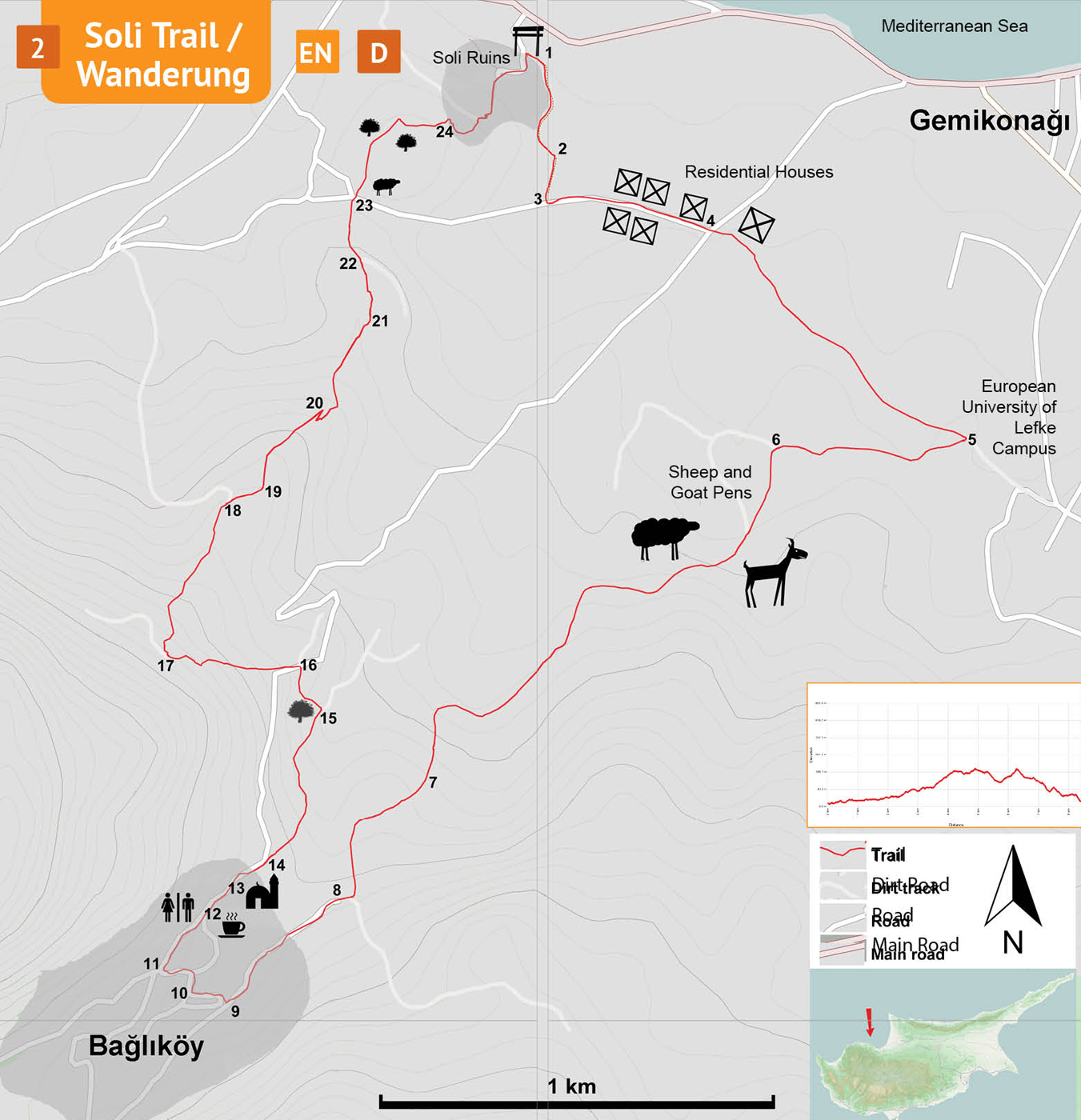
Start / End: The trailhead is the enterance gate of Soli Ruins near Yedidalga Village.
Distance: 8,5 kms
Duration: 3 – 4 hours
Ascent: +300 m
Difficulty level: Moderate
Notes:
· This trail is not marked but overlaps partly with two other trails, one marked with green-yellow and another one with red-blue paintmarks.
Trailgate
(1) – Bağlıköy (8)
Soli Trail starts at the trailgate located at the enterance of the Soli Ruins (1). Facing the trailgate, turn L and follow the asphalt road along the fence of Soli. The fence is set on a road cut in the hillside, where you can see many pottery shards originating from the ruined Roman town. The fence ends in about 200 meters, but keep on the road curving L, with fruit trees on both sides. Many pomegranates, oranges and olive trees are grown in the region. Where the asphalt ends, the trail follows the gravely dirt track curving R (2) with olive trees on the right and Jaffa oranges on the left. Arrive at a junction (3) and turn L. Walk along the fence and reach an asphalt road (street name: Müze Sokak) in a neighborhood. Müze Sokak ends at the junction with the mainroad (4) to Bağlıköy. Cross the main road to continue on the dirt track passing through more fruit orchards. As the track curves R the campus buildings of the European University of Lefke will appear in the distance. Quite close to the campus, there is an information board with the map of one of the other hiking trails. Turn R at the information board (5) onto a track climbing up a gentle slope to flatten out again soon. The trail follows the main track meandering through arable fields. At the next junction (6) marked by a tall and thorny Zyziphus bush, turn L, climbing a moderate slope, pass by goat-pens put together from rusty metal sheets. Keep on the main track curving R and up a steep slope. On the right, there is an expansive view of a green valley, and, on the left is a hillside with isolated olive and carob trees. Track undulates over the hills and then climbs up curving L. The valley on the right is lush green with well-tended olive groves. A little further an old water-pipe runs along the trail. The trail flattens as it passes through a small pine grove. The track curves L to climb a steep slope. Midway to the end of the slope, there is a small farmhouse on the left (7) with a trellis for grapes, an irrigation pool, a concrete platform and a ditch. The trail passes through small hills and up another steep slope. At the top of the highest hill in the distance, there is a small watchtower. Continue walking up a gentle slope along a deep valley on the right. At the crotch of this deep valley, follow the hairpin corner of the track to right and the village of Bağlıköy starts rising behind the hill. On the left, there is a sign for the forbidden military zone - do not turn into the military zone, keep going straight into the village. Pass by an almond orchard on the right and arrive at the asphalt (8) road.
Bağlıköy
(8) – Trailgate (1)
About 200 m from the start of the asphalt road, find an old concrete fountain on the left (9) and turn half-right down onto a steep downhill brick-paved road. There is a fine example of a traditional mudbrick house on the right. At the bottom of the paved road, turn R. Pass by a historic sandstone fountain on the left and follow another brick-paved road leading up to a junction at an asphalt road (10). Turn R, and then L, pass by a very small shop at the corner (11), and turn R onto Şht Hüseyin Muzaffer Street. About a hundred meters ahead on the right, is the cafe of the village ecotourism association (12). The association “Bağlıköy Ekoturizm Gönüllüleri Derneği” is running the cafe and it is usually open from 8:00 am to late evening, serving homemade drinks, tasty pastries and traditional fruit preserves. Follow the main road down a gentle slope, passing by an information board, the Bağlıköy Mosque (13), and the Atatürk monument. Then, the road curves right and then left near a two-storey yellow house. Here, across the yellow house, turn half-R, into an inconspicuous track, to the right of the tall cypress trees (14), leading down a moderate slope. Walk straight down the valley on the path passing by a small group of eucalyptus trees. There are green and yellow markings on the boulders. Pass by two ruins of old houses and onto a dirt track and then turn L up a moderately sloping track after the carob tree (15). Climb up the track to reach the main road (16). On the main road, turn L and walk for 30 m to turn R onto a dirt track . Walk uphill on the track. This area has an exceptional view of the whole coastline.
There are many signs saying “Avlanmaya yasak bölge” which means “Hunting forbidden area”.
In about 200 m, arrive at a junction (17). Turn right and walk on the track down a moderate slope. The track is laid out on top of the ridge with valleys on both sides. Probably it is the best part of the walk with superb views of the Troodos foothills on the left and the Güzelyurt Bay on the right with Beşparmak Mountains rising from the Mediterranean horizon. After a flat part, abandon the track where it makes a sharp corner to left (18) and keep going straight to stay on the ridgetop. Follow the top of the ridge to the summit of the next hill. Turn left (19) and follow the ridgetop and head in the direction of the pier at the seaside. At the end of the ridge (20), turn right and zigzag down the hillside to another narrow track, turn left again towards the sea. Walk down a moderate slope and then straight up to the hilltop. Follow the track passing by two old military bunkers (21) down and turn left at the junction (22), passing by small caves. After the second junction, arrive at a crossroads (23) by a sheep-pen. Walk straight across, passing under the fig tree, to go up the carob trees on the hill behind the sheep-pen. There is no single path here, walk towards the big carob trees and turn right. Pass by the ditches towards the fenced area of Soli ruins. There is a gate / opening (24) in the fence on the left side. Pass through the opening and arrive at the top of the Soli amphitheater. Take the paved steps down to the parking area of Soli and to the trailhead near the enterance (1).
Difficulty Levels
Easy: Flat to slight slopes
Moderate: Moderate Slopes
Difficult: Trail with Steep slopes
Very Difficult: Trail with very steep slopes requiring scrambling