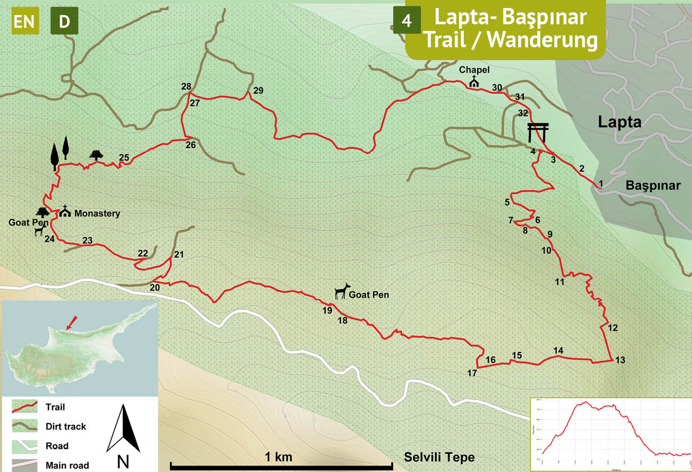
Use the trail map
together with the detailed descriptions to follow the trail.
Lapta
Trail
Trail
Info:
Location of the Trailhead: The trailhead is the information board in the small square known as the “old Başpınar spring” in Başpınar neighborhood of Lapta village.
Distance: 9,5 km
Duration: 4 – 5 hours
Ascent: +900 m
Difficulty level: Difficult
Notes:
· The blue and red paintmarks on the trail are not well maintained and missing in some sections.
· This trail overlaps partly with another trail marked with green-white.
· This is a difficult trail with long stretches of steep climbs.
Başpınar
(1) – Lime Kiln (9)
Face the information board (1) in the small square near the old spring of Başpınar. Turn R and walk past the “Villa Başpınar” and the giant plane (Platanus) tree to the dirt track. Walk along the retaining wall on the left and take the left track at the fork (2). There are white-green paintmarks. Follow the main track straight on for about 100 meters to arrive at the second fork (3). Again, take left track climbing up a moderately slope. At the top of the climb, arrive at a flat area and find the narrow path (4) 20 meters ahead, on the left side of the track, by the trailgate. Leading up a steep slope, the narrow path is very conspicuous and marked with red and blue colors on the rocks. Follow the trail up the mountain side with sharp hairpin turns, ignoring the lesser paths branching off especially at the corners. After climbing a little bit, the trail curves L and then R and comes to the base of a sheer rock cliff (5). There are blue arrows on the rock pointing in both directions, turn L. Follow the path, making sharp turns (6). After passing through a wooded area (7), arrive beneath another tall cliff with pink flowered oleander plants. Turn L to follow the trail, passing on the right side of a chunky rock further up the slope. Climb up curving R, scrambling over boulders and then walk down a gentle slope (8). Follow the path through a pine forest and pass by an old lime kiln (9) overtaken by a big turpentine tree (lime kiln is a circular open-top building made of stones).
Lime
Kiln (9) - Monastery
After getting out of the pine forest (10), the trail heads up the mountain on a path curving L, full of broken up limestones. Pass by an old retaining wall (11) and walk snaking up on a steep path with big rocks and turn L on a less steep path.Trail continues to zigzag up through cypress trees (12), an open space, and then enters into a pine forest. The path slaloms through the pines, makes a R turn(13) and passes by a big fallen tree (14) to the left. In the distance, a transmitter is situated on top of Selvili Tepe (Mount Cypress), the tallest peak of North Cyprus, with the antennae visible. Walk a short downhill section curving R to flatten out. Walk by an open top water – well (15) and turn half-L to climb a moderate slope in a thoroughly established climax forest of Calabrian Pines. There is a ruin to the right (16). Turn R to leave the tall forest (17) curving R and then L to go behind the hill. Descend curving L and enter into another wooded area to descend further passing by a retaining wall (18) in an area with low thorny bushes. Arrive at a dirt track (19) giving access to the nearby goat-pen. Follow the track climbing up a moderate slope to end at a junction (20). Turn R and follow the trail zigzagging down the mountain. Respectively turn L at the next junction (21), and then L again (22), and then R (23). At the end of the dirt track (24), the trail continues as a narrow path. Pass by a goat-pen and down to a steep slope towards the ruins of a monastery (Panayia Kriniotissa) and turn L.
Monastery
– Dirt Track (26)
The trail literally passes through the two halves of an olive tree whose trunks have inched away from each other over the centuries. Curve R down a steep slope passing through a growth of giant cypress trees. There are two trails in this area marked with blue paint. Curve L through a rocky area and then follow the trail turning R to go down a steep slope with a lot of loose rubble. Further down the trail there are many big carob trees, some of them dead and rotting. Pass by a giant olive tree to the right and another giant olive trunk lying along the trail (25). Walk on the barren hillside and arrive at the dirt track (26).
Dirt
Track (26) – Başpınar (1)
Turn L, downhill, passing by another lime kiln (27) to the right, to find a crossroads (28). Turn R on the dirt track marked with red and white-green paint. Arrive on the next junction (29) and turn R to keep on the main track. Follow the main track along the contour, ignore the smaller side tracks leading down and pass by a graveyard with a collapsed chapel. Soon after the graveyard, turn R at the junction (30) to climb up a steep slope to arrive at the next junction (31). Keep on the main track and curve R and then L, passing by a single-room ruin (32) to the right, and then an abandoned villa to the left. At the next junction (3) turn L to arrive at the trailhead (1) in about 100 meters.
Difficulty
Levels
Easy: Flat to slight slopes
Moderate: Moderate Slopes
Difficult: Trail with Steep slopes
Very Difficult: Trail with very steep slopes requiring scrambling