Use the trail map
together with the detailed descriptions to follow the trail.
Kumyalı
Trail
Trail
Info:
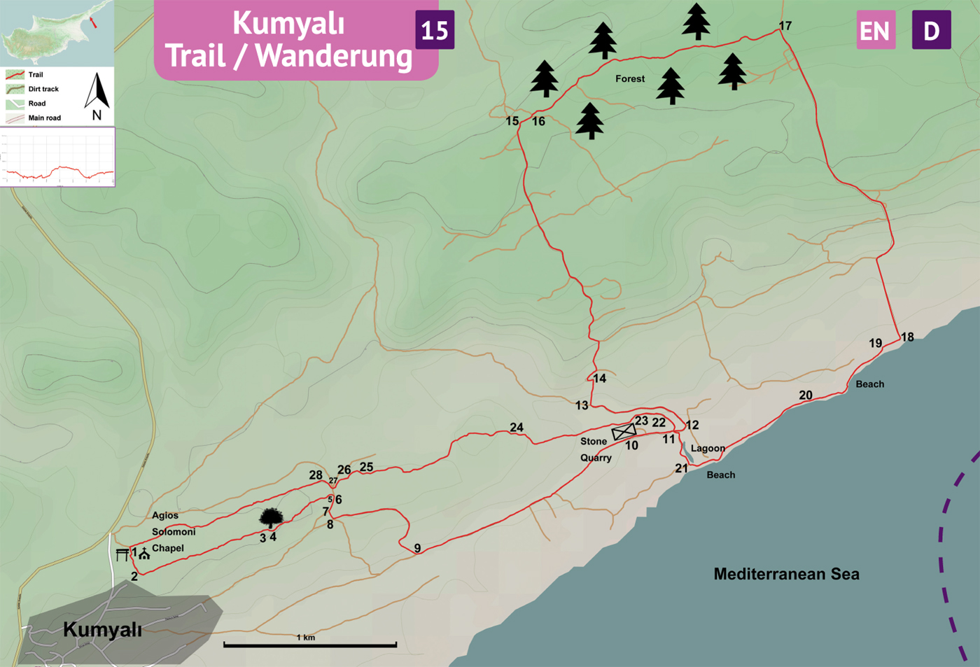
Start/End: There are two enterances to Kumyalı village from the main road. The trailhead is near the eastern enterance to the village. 50 m south of the eastern enterance there is a small chapel on the hill visible from the main road. The trailgate is next to the chapel.
Distance: 16 kms
Duration: 5 – 6 hours
Ascent: +250 m
Difficulty level: Easy / Moderate
Note:
· The trail is in the shape of a figure “8” so it is possible to walk two halves (8 kms each) separately.
Trailgate
(1) – Pyramid P92 (11)
The trailhead is by the Ayios Solomoni chapel. This section of the trail is defined with yellow-green, red, red-white, white paintmarks. Find the trail gate (1) by the chapel. Start from the trail gate and go 130 m south and curve left (2) towards east, following the paintmarks and the sequenced rocks. Walk for 750 m in this region of flat rocks and squat trees. Pass between two waist-high rocks (3) to start descending into an area with denser vegetation. About 40 m ahead, turn L at the carob tree (4), following the trail to east. Walk through the dense woodland for 430 m to arrive at the edge (5) of the plateau. Climb down the steep hillside to the dirt track near the big carob tree (6) with two trunks. Turn R at the dirt track in front of the carob tree with two trunks and follow the dirt track 100 m curving west. At the junction (7), turn L and walk for 50 m to reach another junction (8). Turn L again towards east to follow the dirt track. 400 m ahead the road curves south. At the junction (9), turn L on the dirt trackand head east. This section of the trail is defined with yellow-green, red-white and white-green paintmarks. The dirt track goes straight to the rock quarry (10) 1,5 kms ahead. Pass by the rock quarry and find a concrete pyramid P92 (11).
For an 8-km walk (3 hours), at the junction(11), turn L (T139) to north.
Pyramid
P92 (11) – Pyramid P93
For the full-length trail (16 km / 6 hrs) go
straight ahead to east (T117) on the dirt track. Follow the dirt track 75 m,
going down to a muddy area and back up to a junction (12). Turn L at the junction towards north (the riverbed is on the
left). Go 630 meters on this dirt track curving west and turn R on the dirt
track (13) dividing the fields
towards north. After passing through the fields, turn L onto the dirt track (14) going uphill. There are
white-green and yellow-green paintmarks on this dirt track. Follow this
meandering dirt track for 1,8 kms to arrive at the third pyramid P93 (15).
Pyramid
P93 – Sandy Beach (19)
At the pyramid 93 leave T117 by turning R onto T140 towards east. At a junction 70 meters ahead (16), turn L to a lesser used narrow dirt track leading northeast into the forest. Follow this double track footpath eastwards, snaking through the forest. About 1,5 kilometers ahead find a wide and straight dirt track (17). Turn R towards south and follow this road (2,25 kms) all the way to the seaside (18). Some parts of this dirt track are asphalt. Arriving at the seaside, turn R to west to walk down to the sandy beach (19).
Sandy
Beach (19) – Pyramid P92 (11)
Head west on the beach. Pass by the rocks 150 meters ahead to the second beach. The second beach is 200 meters wide. At the end of the second beach walk onto the rocks. Walk for 330 meters on the rocks following the shoreline to arrive at another sandy beach (20). Continue walking west on this beach and 700 m ahead find a fresh-water lagoon on the right. Turn R (21) after the lagoon. Walk along the west side of the lagoon on the dirt track for 230 meters. Turn L to find the pyramid P92 (11).
Pyramid
P92 (11) – Trailgate (1)
From Pyramid P92 take T139 by turning R towards north. The trail becomes narrower (riverbed on the right). 120 m ahead there is a big stone gutter (22) running down into the riverbed. The trail curves left to head west. 150 m from the gutter, turn L (23) to climb up the steep hillside. On top of the hill arrive at a building by the stone quarry. Turn R and walk along the cut bedrock towards west. At the northwest corner of the stone quarry, follow the narrow footpath leading west. This section of the trail is defined by red, red-white and yellow-green paintmarks. Passing through the forested areas and the flat bedrock, follow the sequenced rocks and paintmarks. Arrive in an open area where there is a yellow diamond sign on an olive tree (24). From this tree, follow the trail 1200 m west. Descend gently on a light slope down (25) and pass by the pine tree (26) to arrive at the dirt track. Go across the road right where it forks (27). Start climbing the narrow footpath curving right, up to the northern side of the hill. At the top (28), follow the trail meandering through the forest for 1300 m to reach a junction. Turn L towards south to arrive at the trailgate (1) in 40 m.
Difficulty
Levels
Easy: Flat to slight slopes
Moderate: Moderate Slopes
Difficult: Trail with Steep slopes
Very Difficult: Trail with very steep slopes requiring scrambling