Use the trail map
together with the detailed descriptions to follow the trail.
Karşıyaka
Trail
Trail
Info:
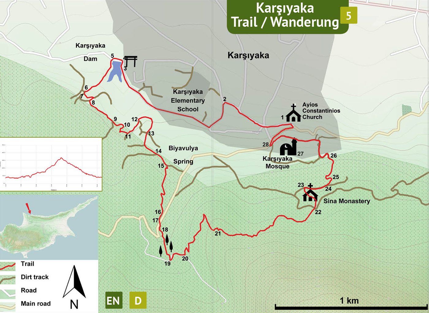
Location of the Trailhead: The trailhead is the Ayios Constantinios Church in the center of Karşıyaka village.
Distance: 6,5 km
Ascent: +400 m
Difficulty level: Moderate
Duration: 3 – 4 hours
Notes:
· This trail overlaps partly with another trail marked with green-white and red colors.
Ayios
Constantinios Church (1) – Karşıyaka Dam (8)
The trailhead is the central church in village center (1) . Facing the church turn L and walk down the main village road for about 500 meters. At the junction (2) turn L, towards the mountain. Follow this road uphill, for about a kilometer curving right and downhill. Towards the end of this dead end road, turn L (3) onto a dirt trackto arrive at the trailgate (4) near Karşıyaka Dam.
Karşıyaka
Dam (4) – Monumental Platanus Trees (16)
Turn L and walk along the dam of a sporadic wetland full of tamarix trees. After the dam, turn L at the junction (5). The dirt track climbs a moderate slope up through carob and olive trees. Arrive at a junction of 6 roads (6). Turn L and then first L again in 15 meters (7), to descend down into a riverbed and then up, curving R and up to the top. At the top, make a hairpin turn to R to come to a junction (8), turn L onto a very steep track. Climb up and in the distance, the majestic view of the Mount Kornos rises. Continue on the flat track, curving R arrive at a junction (9) and turn L down into the valley. At the bottom, pass over a weak stream (10) and then up curving L to come to the junction (11). Climb on and at the next junction (12) the trail becomes a narrow path (12), curving R further along a stone fence and arrive at a crossroads (13). Go straight up the hill and then curve L climbing up. Pass by a house (14) on the left. Walking down into another riverbed, turn L onto a narrow path (15) across giant plane (Platanus) trees on the side of the track.
Note: Further down in the shade of the trees (15) there is a small fountain called “Biyavulya Spring” with potable water.
Monumental
Platanus Trees (15) – Narrow path (20)
Follow the narrow track curving R to the next terrace up the hill. Follow the goat tracks on the hillside just below the cypress forest along the historic terraces built for cultivation of olives and carobs. Soon after the terraced area walk down into the riverbed going upstream. Pass by a eucalyptus tree with a massive trunk (16) and turn R after 50 meters near a leaning olive tree (17) to go up to the asphalt road just 15 meters. Cross the road, turn R along the partly collapsed terrace. Pass by a big walnut tree (18) and find a small riverbed with soft surface and a pipeline. Follow the pipeline into the cypress trees and come out on the other side on a narrow and moderately steep path. Use the goat paths to reach the dirt track (19). On the dirt track turn L uphill, curving R. Pass the bridge on the dirt track and about 30 meters beyond the bridge on the left starts a narrow path (20).
Narrow
Path (20) – Karşıyaka Mosque (33)
Zigzag up the mountain on this trail marked with green – white and red colors. Ignore the minor goat tracks at the hairpin turns. At the top (21), the view of the monastery down below is truly rewarding. Follow the well defined narrow path along the mountain side to reach the monastery (Sinai Monastery). At the end of the narrow path arrive at the dirt track (22). Follow the old aqueduct into the quarters of the monastery, passing through the collapsed rooms to come out at the front. Walk down to the flat area and turn R (23) onto the dirt track down a gentle slope, leading to Karşıyaka village below. The track forks (24), take the L, downhill. There is a fenced water station (25). At the water station, turn L to follow a narrow path leading down to the village through the old Turkish quarter of the village with lots of cypress trees. Arrive at the paved road near a yellow villa with a swimming pool (26). Follow the paved road down, passing onto the asphalt and continue towards the mosque (27).
Karşıyaka
Mosque (27) – Ayios Constantinios Church (1)
Pass in front of the mosque. At the junction (28) turn R and walk down the street to the village square (1) to the Ayios Constantinios Church.
Difficulty
Levels
Easy: Flat to slight slopes
Moderate: Moderate Slopes
Difficult: Trail with Steep slopes
Very Difficult: Trail with very steep slopes requiring scrambling