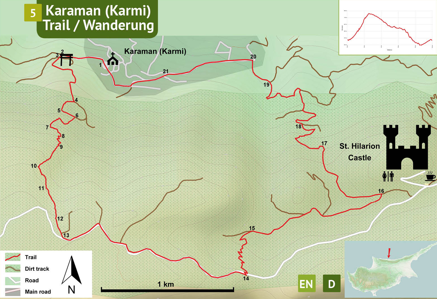
Use the trail map
together with the detailed descriptions to follow the trail.
Karmi Trail
Trail
Info:
Location of the Trailhead: The trailhead is located in the village center of Karaman in front of the church.
Distance: 9,5 km
Duration: 4 - 5 hours
Ascent: + 700 m
Difficulty level: Moderate / Difficult
Notes:
· This trail is marked with blue, and overlaps partly with another trail marked in green-white colors.
· The trail has a very long and enduring sections of uphill and downhill climbs.
· Visiting St. Hilarion Castle is not included in the given disance, duration, ascent and difficulty values.
Karaman
Village Center (1) – Asphalt Road (13)
The starting point of the trail is the square (1) in Karaman village center. With the church main enterance at the back, follow the asphalt street towards west, walking downhill on a moderate slope, curving L to climb a moderate slope up. Continue on the street, changing from asphalt surface to concrete surface and ending at a dirt track (2). Turn L to arrive at a crossroads (3) 50 meters away. Go straight onto the dirt track passing by the trailgate, leading up the mountain on a steep slope. Curve L, and then R, R again and then L on a steep but fairly straight section. In about 150 meters from the last curve, there is a stone cairn (4) to the right, indicating where the narrow path starts. Turn R, abandoning the dirt track to get onto a very narrow path through the rockrose bushes. Although the track is very narrow, it is well-travelled and marked with blue paint on rocks. Arrive another dirt track (5) and turn L to walk on this flat section of the trail. St Hilarion Castle in the distance is almost at eye-level. Abandon the dirt track again at the cairn (6) on a bare rock. Climb up on a narrow track, curving L and then R to climb up the hillside and scramble up on a rock turning L (7). Narrow track climbs further up passing by a small cave (8) and the winding narrow path relentlessly climbs up the mountain. Path turns a corner (9) from north-facing slope to the east-facing slope climbing up an initially moderate but then very steep slope into a pine and cypress forest. Turn L at the natural spring (10) which is yielding the taller vegetation within this valley. Pass through the smooth-barked strawberry trees and over a pipe and a cable (11). The narrow path ends at an open space (12) under tall trees where a dirt track links to the asphalt road (13).
Asphalt
Road (13) – Dirt Track (18)
Turn L on the asphalt road to go east on a gentle slope down towards the St Hilarion Castle. Follow the asphalt for about 1,5 kilometers and find the beginning (14) of the narrow path indicated by a concrete pyramid (P11). From the asphalt road, make a hairpin turn down into the narrow path on the hillside leading down all the way to a dirt track at the bottom. This trail is marked with both green-white signs up to the Karaman village. On the dirt track (15) turn R towards St Hilarion Castle. Walk on the main track to another concrete pyramid (P13) located at the junction (16). Turn L onto a narrowing track along a riverbed. This part of the trail is marked with both green-white and green-yellow signs. Pass through lentisk, turpentine and pine trees curving R towards the north coast through a rocky canyon, well-eroded by the occasional flash floods. Follow the water-course coming down from the canyon over limestone boulders. Two paths lead out at the end of the canyon, take the one on the L. Climbing up on a moderate slope through very spiny Genista bushes. Arrive at an open space (17) with an expansive views of the north coast with Kyrenia on the right and Alsancak on the left. Follow the track curving L and descending down the mountain at a dangerously steep and slippery path. Zigzagging all the way down to a dirt track (18), the last part passes through tall Oryzopsis grasses.
Dirt
Track (18) – Karaman Village (1)
Turn L onto the dirt track on a moderate slope dowhill. Stay on the main dirt track ignoring the smaller paths branching off and descend considerably down on this curving journey. Arrive at a major junction (19) and keep going straight on a moderate slope up, curving R to reach the asphalt village road (20). Turn L on the asphalt and walk up moderate slope on this fairly straight street up to a T-junction (21) with the main road of Karaman village. Turn L and follow the winding road to village center (1).
Difficulty
Levels
Easy: Flat to slight slopes
Moderate: Moderate Slopes
Difficult: Trail with Steep slopes
Very Difficult: Trail with very steep slopes requiring scrambling