Use the trail map
together with the detailed descriptions to follow the trail.
Kalkanlı
Anıt Zeytinler Trail
Trail
Info:
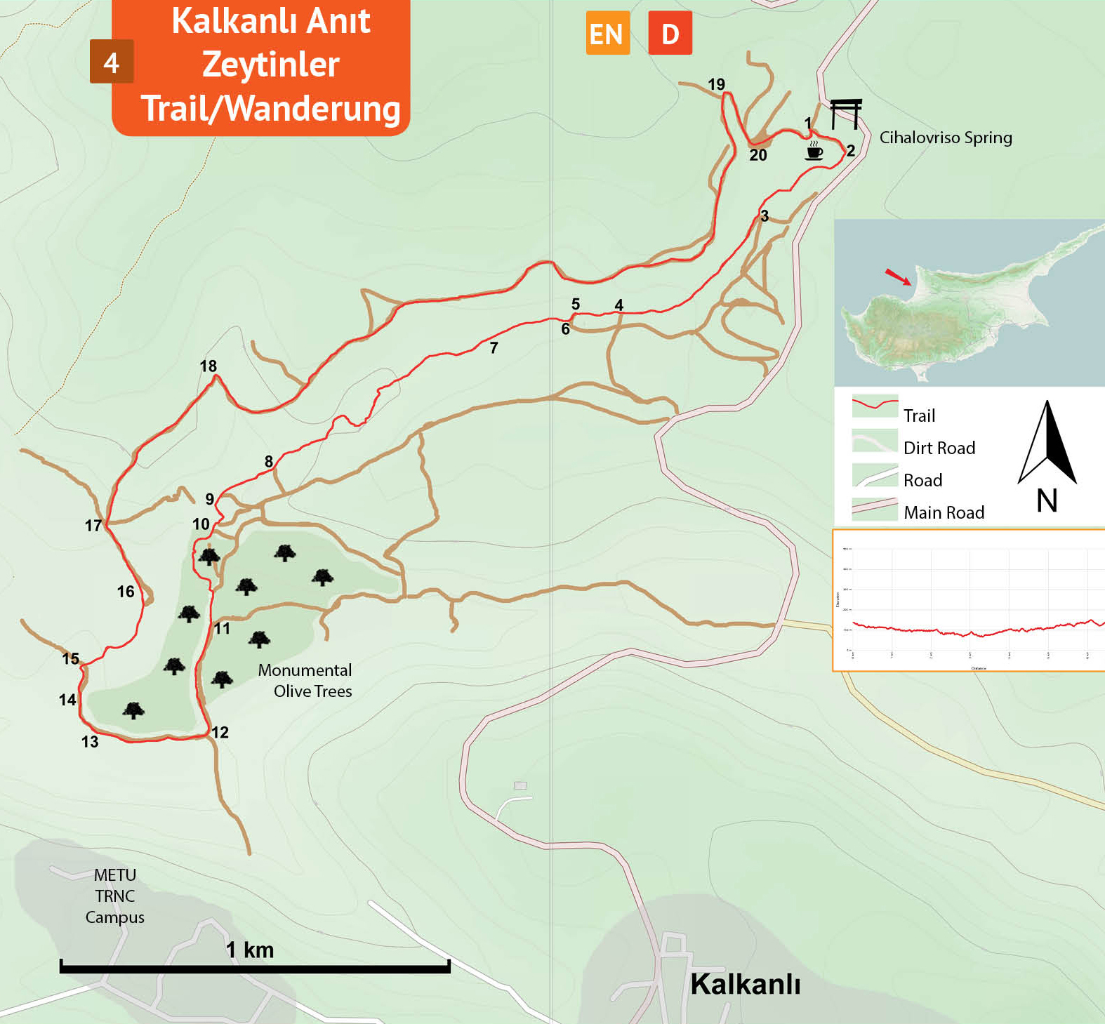
Location of the Trailhead: The trailhead is located near the roadside cafe / picnic area between Tepebaşı and Kalkanlı villages.
Distance: 6,5 km
Duration: 2 – 3 hours
Ascent: +130 m
Difficulty level: Easy / Moderate
Notes:
· This trail is not marked but overlaps partly with another trail marked with green-white and occasional blue paintmarks.
Kalkanlı Anıt Zeytinler (Monumental Olives) Trail
Trailhead
(1) – Water tank (10)
Trail information board (1) in front of the cafe/restaurant is the starting point for the trail. From the information board turn L and walk down to the spring (2). Cihalovriso spring is one of the very rare permanent springs in North Cyprus. The water has three points of origin and merge toghether at a concrete basin to run in a single aqueduct. The first two kilometers of the trail extends parallel to the water channel. Walk along the aqueduct down on a gentle slope, through a narrow passage in a bush of thorny blackberries and a fig tree. Pass by the giant eucalyptus trees and flow with the water into the lush green valley. There are several tracks and paths in this area, stay on the path closer to the aqueduct. About 300 meters from the spring there are several steps (3) and at the top, turn R. The trail undulates along the side of the valley. After the climb, turn right back down to the water on a narrow path again. The trail continues along the valley side quite a while and then crosses a dirt track (4) and the well defined path, going down to the aqueduct and back up, leads to another dirt track in about 500 meters. Curve L on the dirt track and then at the junction (6) turn R and walk on the narrow path again in the pine forest to lead to the water. Cross over the aqueduct via a steep embakment of about two meters and walk under the dense canopy. Pass by the wooden bridge (7) and continue walking immediately along the aqueduct. Stay with the aqueduct ducking under carob trees, passing through a shady pine forest until reaching the iron gate (8) of a fenced area. The fence is against goats mutilating the monumental olive trees. Open the gate and walk through continuing along the aqueduct until where a section of the aqueduct is covered with concrete slabs (9). Here, turn L onto a dirt track curving L, and then R on a narrow path to end up down in an open space area (10) with an information board, wooden seats under a big carob tree and a large water tank. This is the tank where the spring water is stored to be used in the olive orchards.
Water
tank (10) – Trailhead (1)
Walk past the water tank on the left side and turn the corner to R and pass under the pine trees on a narrow path. Curving left, the path ends at a majestic monumental olive tree. This tree is called “the King” as written on the label. On top of the hills in the distance there are large buildings of the Middle Eastern Technical University. From “the King” head in the direction of the buildings (southeast-south) passing through the olive trees to find the access road of the orchard. On the dirt track, roughly in the middle of the orchard, there is an open space (11) there are information boards.. Feel free to wander around and find other monumental olive trees with labels and come back to the information boards. Continue on the dirt track in the direction of the campus buildings to find a big gate (12) in the fence. Get out of the orchard at this gate and follow the dirt track curving R along the fence. Pass by the ruins of Ayios Mandilios church (13), a small gate (14), a big gate (15), and then turn R to keep walking along the fence. Climb up a steep slope and continue to walk along the fence curving L to find another big gate (16). Refrain from following the fence further and follow the dirt track leading away from this gate. There is a junction (17) in about 150 meters, turn half-R (not the immediate R) and pass by a fixed cairn by the road. Follow this dirt track with a gentle slope up in a sparse pine forest to the sharp corner (18) to the right and then curving L. This fairly wide dirt track follows roughly the edge of the cliff overlooking the valley all the way (nearly 2 kms) to the picnic area behind the cafe/restaurant. Make a hairpin (19) R - turn, down on a steep slope to pass through this picnic area (20) and then back up a steep dirt track to reach the trailhead by the restaurant (1).
Difficulty
Levels
Easy: Flat to slight slopes
Moderate: Moderate Slopes
Difficult: Trail with Steep slopes
Very Difficult: Trail with very steep slopes requiring scrambling