Use the trail map
together with the detailed descriptions to follow the trail.
Kaleburnu
Trail
Trail
Info:
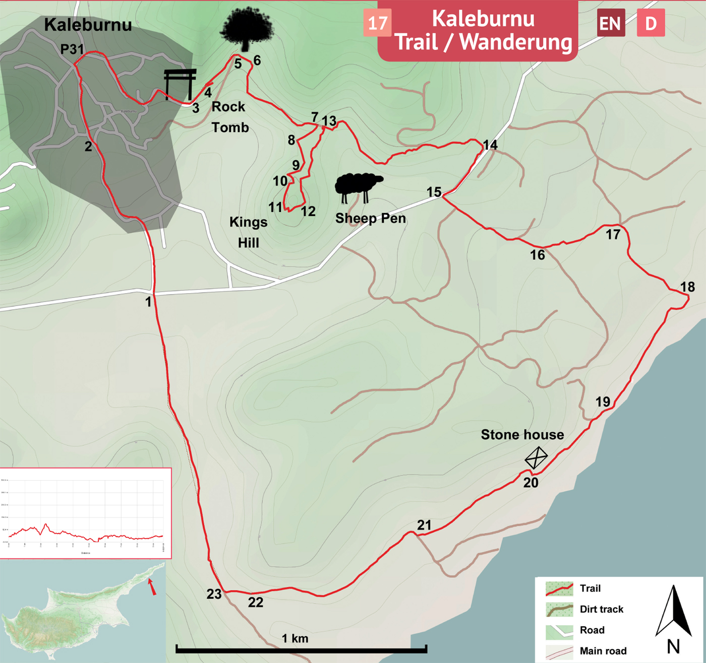
Location of Trailhead: Trail Information Board at village junction.
Distance: 10 km
Ascent: +300 m
Difficulty level: Moderate / Difficult*
*If the Kings Hill section is excluded, the difficulty level becomes “easy”.
Trail
Information Board (1) – Gastros (3)
Turn R in front of the trail information board (1) located at the junction between the main road and the road to village. The section of the trail is defined by white-green paintmarks (from the information board, all the way to the trail gate at Gastros). 400 meters ahead of the information board is the Kaleburnu Cultural Center. Continue on the asphalt road passing to the left of the Atatürk statue (2) to the coffee house at the village square. Pass the coffee house to north 50 meters to find pyramid P31. Turn R to west and follow the paintmarks on the winding village streets to the location called by the villagers as “Gastros” or “Ayanna” (3).
Gastro (3)
- Kings Hill
Pass by the trail gate and the wooden park benches situated on the cliff. This section of the trail is defined by white-green and yellow-green paintmarks. 75 meters ahead there are wooden steps (4) which descend into the Gastros Rock Tomb (dead end path). From the top of the steps, for 175 meters, the trail goes along the cliff with a slight downhill slope. At the bottom of the hill turn R. Pass between a big carob tree (5) on the right and a retaining wall on the left to the wooden bridge (6) straight ahead. The footpath becomes wider after the bridge. Continue on the path curving left for 700 meters. The steep hill on the right is the “Kings Hill”.
Kings
Hill
(In order to continue without climbing up and down the Kings Hill, do not turn R, keep going straight on the dirt track)* *.
Turn R (7) at the end of 700 meters to a dirt track leading to the fields at the bottom of the hill. Turn L at the field and 10 meters ahead turn L (8) again to start climbing the hill via a narrow footpath. Walk uphill through thorny bushes and turn R following the stone steps. The trail climbs up towards west on the right side of the hill. Step onto the crystalline gypsum rock (9) in the ground and turn L and just 4 meters ahead turn R by the rock to climb another set of stone steps. The village is in the distance on the right. Follow the trail up a steep hillside and turn L (10) to reach the top. Cross the flat top of the hill along to the southern edge (11). At the south end of the flat top, turn L to descend towards north. Zigzag down the steep hillside to the big terrace area (12) where there is an archaeological dig site. Continue on the trail to north for 300 meters from the dig site to reach the dirt track (13), passing by a big boulder of gypsum rock.
**Turn R at the dirt track to go east. Pass by the metal gate and continue on the dirt track to reach the asphalt road (14). Turn R towards west on the asphalt road and walk for 280 meters to find the dirt track (15) on the left.
Kings
Hill - Asphalt Road (14)
Asphalt
Road (14) – Trailhead (1)
Abandon the asphalt road by turning L onto the dirt track. 400 meters ahead, the road splits (16) into two, take the L. Arrive at a four-way junction (17) 380 meters ahead. Turn R towards south and walk 400 meters on a slightly downhill road to reach the seaside (18). Turn R at the seaside towards west. Walk along the sandy beach. At the west end of the beach, walk on the narrow footpath (19) climbing up the hill to reach a flat area overlooking the sea. Follow the slightly downhill dirt track going west to the fields. Walk along the right side of the fields and arrive at a small stone building at the edge of a hill. Find the dirt track by climbing up passing between the stone building (20) and the swine stables. Continue walking west on the dirt track and along the left side of the fields for 550 meters. In this area, it is possible to see the Cila island off the shore. At the end of 550 meters, find the dirt track again and turn R (21) and walk for 30 meters. Turn L and follow the dirt track towards west. Pass by two big boulders (22) on the left and right side of the dirt track. Turn R at the junction (23) towards north. This fairly straight dirt track ends at the trailhead (1) in 1200 meters.
Difficulty
Levels
Easy: Flat to slight slopes
Moderate: Moderate Slopes
Difficult: Trail with Steep slopes
Very Difficult: Trail with very steep slopes requiring scrambling