Use the trail
map together with the detailed descriptions to follow the trail.
Esentepe
Trail
Trail
Info:
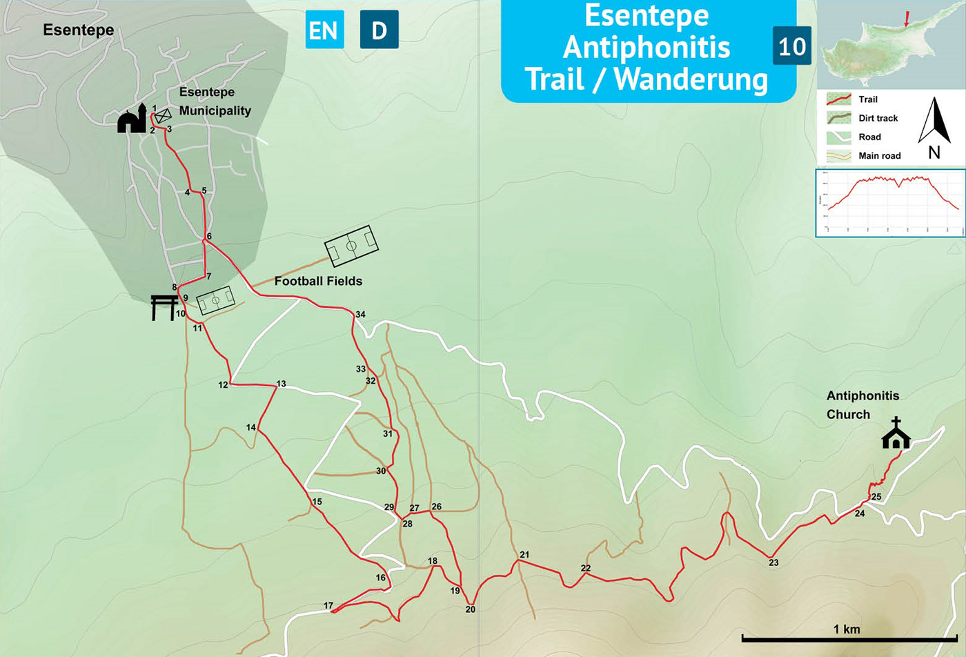
Start/End: The trailhead for this trail is the front of Esentepe Municipality located in the middle of the village of Esentepe.
Distance: 13,5 km
Duration: 4 - 5 hours
Ascent: + 700 m
Difficulty level: Easy
Notes:
· This trail is not marked, but partly overlaps with other trails marked in different colors.
Esentepe
Municipality (1) – End of Asphalt (9)
The trailhead is the front of the Esentepe Municipality building (1). Facing the municipality building turn R and then L to pass between the municipality building to the left and the mosque (previously church) to the right. At the junction (2), turn L and then R (3) onto “Gümüş Sokak”. Walk up this meandering street on a moderate slope up. Pass by the health center and arrive at a T-junction (4). Turn L and then R (5) onto “Dr. Salih Miroğlu Sokak”, to find the roundabout (6) at the end of the street. Go straight past the roundabout towards the primary school, passing the police station to the right. At the primary school, turn R at the corner (7) onto “Kenar Sokak”, and then L at the junction (8). Walk straight to the end of the asphalt street.
End of
Asphalt (9) – Spring (20)
Reach the first fork at the end of the asphalt (9) and take the R, and then the second fork (10), and take the L dirt track climbing on a moderate slope up. Pass by some work machinery behind the fence to the left. At the junction (11), turn R towards the mountains. This section of the trail has circular paintmarks colored green and white. Pass through a sparse forest and arrive at the asphalt road (12). Walk on the asphalt road for about 200 meters and turn R onto the dirt track (13) just after the electricity pylon. There are no green - white paintmarks in this section. Follow the dirt track and turn L at the junction (14) onto a long stretch of moderate climb up to the mountain. Keep on the dirt track, passing by the asphalt road at one point. Turn L at the junction (15) to continue on the dirt track, pass by the asphalt road again and then find the next junction with the asphalt (16). Turn R and walk on the asphalt curving R and then curving L and in about 350 meters arriving at a junction (17) with an old signpost. Make a hairpin turn to L onto the narrow dirt track. This is the historic road for the Antiphonitis Church. Follow this mostly flat narrow dirt track along the contour line of the mountain. Turn R at the junction (18) and continue on the track to arrive at the next junction (19). Turn R, on flat track curving R, to arrive at a small water fountain with the picnic area (20) on a bend with some wooden benches and mint growing in the drainage.
Spring (20)
– Antiphonitis Church
Continue on the dirt track and pass a wide firebreak (21). Walk by the pinnacle rock (22) and then a large water tank (23) and arrive at the asphalt road (24), where there is a concrete pyramid (P9). Cross the road in the direction with the road sign “Antifonitis Kilisesi / Church”. Walk down the asphalt road and to the left there is a small concrete pyramid with a graffiti red arrow. This is the beginning of the narrow path (25). Follow this winding path all the way down to the front gate of the church.
Antiphonitis
Church – Esentepe Municipality (1)
After visiting the church, go back the same narrow winding path up to the end (25). Walk up the asphalt, cross the road (24) and pass by the concrete pyramid (P9) and follow the same dirt track back. Pass by the large water tank (23), then the pinnacle rock (22) and the firebreak (21). Take notice of the picnic area with the water fountain (20), and turn R at the next junction (19), to walk down on a long stretch of a moderate slope. There is a series of junctions, respectively turn (26) L, again (27) L, turn (28) R, and then again (29) R. At the next junction (30), turn R and walk down on the dirt track cut into the bank of the ravine. Turn R at the next junction (31) and keep going straight through the next two junctions (32, 33) to arrive at the asphalt road (34). Turn L towards the village and follow the asphalt road down on a gentle slope back to the roundabout (6). At the roundabout, turn R again on “Dr. Salih Miroğlu Sokak”. At the junction (5) turn L, and then (4) R, (3) L, and then (2) R again to finish near the municipality building (1).
Difficulty
Levels
Easy: Flat to slight slopes
Moderate: Moderate Slopes
Difficult: Trail with Steep slopes
Very Difficult: Trail with very steep slopes requiring scrambling