Use the trail map
together with the detailed descriptions to follow the trail.
Büyükkonuk
Trail
Trail
Info:
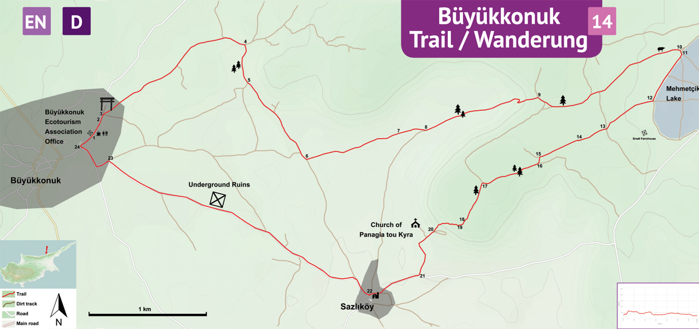
Start/End: The trailhead is the office building of Büyükkonuk Ecotourism Association in Büyükkonuk Village.
Distance: 13,5 km
Duration: 4 - 5 hours
Ascent: +150 m
Difficulty level: Easy
Büyükkonuk
Ecotourism Association Office (1) - Mehmetçik Wetland (12)
Trailhead is the office building of Büyükkonuk Ecotourism Association. Facing the office building (1), turn R towards east and follow the asphalt, village street curving L. In about 150 meters, turn R (2) down on a street named “Zeytin Yolu” and go straight to leave the asphalt and to get onto a dirt track (3). Walk on this fairly straight and flat dirt track with fields and scattered olive trees on both sides. The track curves right and comes to a junction. At the junction (4), turn R. Further ahead, pass by a small group of pine trees and at the fork (5), take the L track. To the left of this straight track there is a line of boulders and further up a naturally vegetated hill. To the right, there are olive trees and fields. Soon the flags are visible in the distance and the track is on a gentle downhill slope. At the junction (6), turn L on this clear dirt track which becomes narrower and less clear further down (7). At the next junction (8), turn L. Further up the track, pass between two pine trees and a lentisk bush. Climbing up the hill, the track gets gradually steeper. Curve sharply to L and then to R to reach the top. Arrive at a junction (9) and turn R to walk down on a gentle slope. Pass another pine tree, and keep going straight on the main track to pass by a vertical water pipe and a fenced orchard. Further to the right, in the distance, there are the houses of Mehmetcik Village, and an expansive flat area which collects water in rainy winters (Mehmetcik Wetland). Walk by a concrete tank to the right and then a sheep pen to the left. At the junction (10) turn R, and then again (11) another R. As the dirt track along the edge of the wetland curves L, turn R at the junction (12) before a small farmhouse on the hillside.
Mehmetçik
Wetland (12) – Sazlıköy (21)
Climb up a moderate slope to a plateau with red soil. At crossroads (13) go straight between fields and occasional carob trees. Pass by a concrete remains of a collapsed water well (14). At the 5-way junction (15), turn half-L and continue on the dirt track and turn R on the next junction (16). Track continues to less intensely cultivated area with rockier ground. The sea is visible to the left, in the distance. Pass by pine trees and arrive at a junction (17) to turn L. Pass by a single pine tree and follow the meandering dirt track until it fades out (18). After the dirt track ends, continue straight to the edge of the plateau, where the escarpment surrounding the plateau is filled in with rubble (19) by shepherds to facilitate climbing of their sheep. Walk down from the plateau, following the stony but well-defined sheep-track down the hillside to join the dirt track down below (20). At the dirt track, turn R and walk down the gentle slope to the junction (21) near village cemetary. Turn R to get onto the asphalt street and walk into the Sazlıköy village. Pass by the mosque in the village center.
Sazlıköy
(21) – Büyükkonuk Ecotourism Association Office (1)
At the junction (22) in the village center, turn R and follow the asphalt road all the way to Büyükkonuk. Pass by an archaeological curiosity about 20 meters from the road. Arrive to Büyükkonuk village on “Sazlıköy Yolu Sokak”. At the junction (23) turn L, and then R at the corner. Curve L and then turn R at the junction (24) to walk straight to the beginning (1) of the trail.
Difficulty
Levels
Easy: Flat to slight slopes
Moderate: Moderate Slopes
Difficult: Trail with Steep slopes
Very Difficult: Trail with very steep slopes requiring scrambling