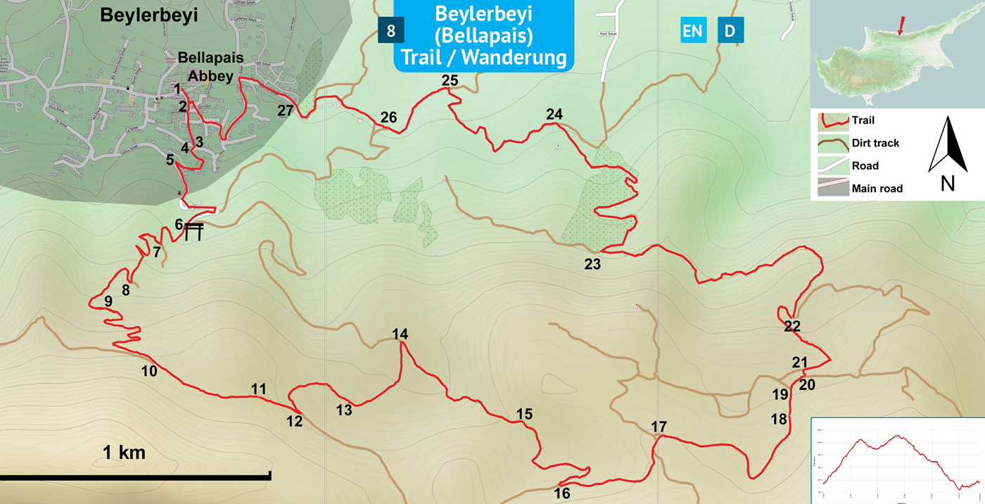
Use the trail map
together with the detailed descriptions to follow the trail.
Bellapais
Trail
Trail
Info:
Start/End: The trailhead for this trail is the enterance of Bellapais Abbey.
Distance: 11,5 km
Duration: 4 - 5 hours
Ascent: + 750 m
Difficulty level: Easy
Notes:
· This trail is not marked, but partly overlaps a trail marked green-white colors and another one with red arrows.
· This trail is laid on asphalt and dirt tracks all the way from the beginning to the end without using any narrow paths.
Bellapais
Monastery (1) – Water Tank (6)
The trailhead is the enterance (1) of Bellapais Abbey in Beylerbeyi (Bellapais) village. The initial part of the trail passes through the narrow village streets leading towards the mountain. Facing the mountain with the abbey at the back, walk on straight to “Zafer Street”, then pass by a small grocery store (2), and get onto “Şht Enver Ali” Street. Follow the moderately steep slope up connecting to the very steep street named Acı Limon. Pass in front of the famous writer Lawrence Durrell’s house (3) and keep going onto the next steep street up. In about 20 meters there is a stone arch on the left. Turn L to pass under the arch (4) and climb the steps in this narrow passageway. There are white-green paintmarks and red arrows in this section of the trail. Walk to the end of the passage and turn R to walk between houses and up a set of stairs under a big bougainvilla plant. Arrive on an asphalt street and walk to the junction (5) of Kemer Street with Tatlısu Street. Turn L and walk uphill following the winding asphalt road until the end. At the end (6) of the asphalt street, arrive at the trailgate near a metal shack and a water tank.
Trailgate
(6) – Roundabout (17)
Take the dirt track immediate left of the metal shack and go straight up on the steep slope curving R and then L to arrive at a junction (7). Turn R up a steep slope. Curve L towards the electricity pylon ahead. Arrive at junction (8) and turn R and on the track curving L. There is the view of western Kyrenia to the right. Continue on a track with a type of ornamental legume trees planted on the side. Pass by a lime kiln (9) to the left (ignore the direction of the red arrows). Follow this winding and steep track up to the junction (10). At the junction, turn L on a moderate slope up and then down on a very gravely track. Pass by another lime kiln (11) to the left. Continue on this fairly straight track down to the junction (12) and turn L to go downhill on a track marked with green-white colors. Pass by another lime kiln (13) which had been cleaned out recently. Pass by pine trees to the right, later curving L on the wide dirt track with a mild downhill slope. Arrive at junction (14) and turn R onto a clean and smooth red dirt track. Curve L onto a steep slope. Pass by old stone retaining walls (15) to the right. Further on, curve L onto white soil dirt track on a moderate slope up to arrive at a junction (16) and turn L. Follow the main track straight to a junction with a roundabout (17).
Roundabout
(17) – Bellapais Abbey (1)
Turn R onto a stony track dividing the mountainside covered with rockrose bushes under infrequently standing wild olives, turpentines and lentisks. After curving L pass through tall cypress trees (18) and arrive at the junction (19) and turn R. Then, there are two junctions close to each other. At the first junction (20) turn L, and at the second junction (21) turn R and follow the dirt track passing through a valley. At the bottom, there is a junction (22) with the option of two left turns, take the first L going downhill along a streambed to the right. Climb up a moderate slope on the track, next to a extraordinarily deep cliff to the right. The trail curves R and around the corner there is a long and steep downhill section. Arrive at the junction (23) and turn R to stay on the main track going downhill. To the left, there are old retaining walls on the hillside for creating terraces. Follow the track over a long stretch of downhill walk to arrive at the junction (24) near a noisy electricity pylon. Turn L. Bellapais Abbey is visible in the hilllside village towards the west. Walk down on the winding track to arrive at the junction (25). Turn L onto a moderately undulating track to the next junction (26). Go straight past the junction towards the village, passing by a house higher up on the hill and then curve around an abandoned construction area with several houses. Find the asphalt street (27) of the village and walk up the street to the junction. Turn L on the road and follow it winding through the village all the way to Bellapais Abbey, the starting point (1),
Difficulty
Levels
Easy: Flat to slight slopes
Moderate: Moderate Slopes
Difficult: Trail with Steep slopes
Very Difficult: Trail with very steep slopes requiring scrambling